24/10/2023-30/10/2023
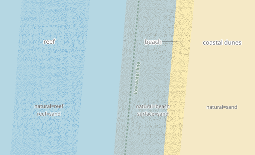
Some OpenStreetMap tags for mapping coastal areas. [1] © Imagico.de
Breaking news
- Over 30,000 people have been displaced by floods in the North Tongu district of Ghana. Stephen Mawutor Donkor is asking for help, on the mailing list, in mapping the affected region.
About us
- Five years of weeklyOSM in Portuguese! That’s right, it was five years ago that we started this adventure of translating (and then revising) weeklyOSM articles into Portuguese. We started with weeklyOSM 431 and now with this issue we have achieved 262 issues uninterrupted! We hope you enjoy our work! weeklyOSM would be much richer if everyone in the Portuguese-speaking community shared articles.Did you know that you can also contribute? Find out here.The editors of the weeklyOSM for the Portuguese language: Elizabete Oliveira and Nuno Azevedo send their warmest greetings from the Azores.
Mapping
- [1] Christoph Hormann explained the basics of mapping coastal geography in OpenStreetMap.
- Vincent de Château-Thierry has announced
![]() , on Mastodon, that the file replacing FANTOIR
, on Mastodon, that the file replacing FANTOIR ![]() ►
►![]() has finally been made available by the French Public Finance Department. This will make it possible to update the content of BANO
has finally been made available by the French Public Finance Department. This will make it possible to update the content of BANO ![]() ►
►![]() and improve street mapping via Pifomètre
and improve street mapping via Pifomètre ![]() in France. Pifomètre enables OSM data and FANTOIR to be reconciled by displaying a list of matched and not yet matched roads, by municipality.
in France. Pifomètre enables OSM data and FANTOIR to be reconciled by displaying a list of matched and not yet matched roads, by municipality. - Ilya Zverev explained
![]() ►
►![]() some of the OpenStreetMap tags needed for mapping trails.
some of the OpenStreetMap tags needed for mapping trails. - A request has been made for comments on
crossing:continuous, a tag for mapping if a footway, cycleway, or similar continues uninterrupted across a road.
 , on Mastodon, that the file replacing
 ►
►Community
- 38446 wrote a diary post about traveling with public transport and asks if one could render the
intervalkey in maps based on OpenStreetMap. - Nombuso and Ibrahim Kamara blogged about mapping eSwatini health data as their project for the open humanitarian mapping community working group mentorship programme.
OpenStreetMap Foundation
- Microsoft has awarded a grant of $150,000 to the OpenStreetMap Foundation. The grant will be channeled towards the improvement and maintenance of OSM infrastructure plus to fund local, regional, and global OSM community activities.
Events
- Topi Tyukanov has published the tasks for #30DayMapChallenge 2023.
- Geomob Finland will be held on Thursday 9 November in the city of Oulu.
- The SotM EU programme has been published.
- The SotM Africa will take place from 30 November to 2 December 2023 in Yaounde, Cameroon. Opportunities for sponsors are available.
- umbraosmbr published
![]() the posters and presentations
the posters and presentations ![]() from SotM Brasil 2023, which were kindly made available by their authors.
from SotM Brasil 2023, which were kindly made available by their authors.
 the posters and
 Maps
- GeoObserver used
![]() Datawrapper to quickly and conveniently create custom map visualisations.
Datawrapper to quickly and conveniently create custom map visualisations.
 Datawrapper to quickly and conveniently create custom map
 OSM in action
- According to the accident statistics of the Social Insurance for Agriculture, Forestry and Horticultural Affairs (SVLFG), forestry work is one of the most dangerous professions in Germany. To make it easier for rescue workers to locate people in need of help, Intend GmbH has published the data set of the KWF
![]() ►
►![]() (Board of Trustees for Forest Work and Forest Technology) in the app ‘Hilfe im Wald’ (help in the forest). It uses OpenStreetMap in the background and has the existing rescue points
(Board of Trustees for Forest Work and Forest Technology) in the app ‘Hilfe im Wald’ (help in the forest). It uses OpenStreetMap in the background and has the existing rescue points ![]() .
.
In 2014 the community in Germany had executed![]() ►
►![]() a weekly task
a weekly task ![]() ►
►![]() (for ‘CraftMapper’). Although the KWF data is under an ‘open licence’, according to information from KWF it cannot be transferred
(for ‘CraftMapper’). Although the KWF data is under an ‘open licence’, according to information from KWF it cannot be transferred ![]() ►
►![]() to OSM because of the licence.
to OSM because of the licence. - A research team from the University of Freiburg have created a global transit map (tram, subway, light rail, rail) using data from OpenStreetMap processed with the LOOM (Line-Ordering Optimised Maps) algorithm.
- Gislars commented on one of the projects included in the OpenStreetMap Hackweekend Berlin 2023: obstbaumkarte.de (Fruit Tree Map). You can hover over a tree on the map to bring up detailed information about it.
Software
- daniel-j-h shared his experience of creating vector maps using Maplibre and Protomaps.
Programming
- Mikhail Sarafanov showed
![]() ►
►![]() how to use the Python library estaty to analyse urban accessibility.
how to use the Python library estaty to analyse urban accessibility. - Rtnf has realised that the OpenStreetMap dataset could be queried using the QLever SPARQL engine.
- Igor Sukhorukov continued to demonstrate applications of his OpenStreetMap H3 tool and this time showed
![]() ►
►![]() how to use it and Graphhopper to assess pedestrian accessibility and attractiveness of housing.
how to use it and Graphhopper to assess pedestrian accessibility and attractiveness of housing.
Releases
- OpenRailwayMap announced some improvements to their search feature. Full documentation of the API for this feature can be found on GitHub.
Did you know …
- … that you can help improve the shoreline and administrative boundary data in OpenStreetMap by using the OSM NightWatch app? The source code for this app is available on GitHub.
- … that the
opening_hourstag has very complicated rules? However, you can use the Web to OSM Opening Hours app to automatically generate the tag from a URL or free text. - … that MapComplete now comes with layer artwork? The data is retrieved in real-time using Overpass or OSM API queries, and you can also add new data to OSM directly through MapComplete.
Other “geo” things
- Some geographical coordinates on Earth have been dubbed “poles of inaccessibility” because they are the most remote point inside a boundary. One of them is Point Nemo, the point in the South Pacific Ocean region that is the farthest away from the shore.
- Nicolas Lambert explained why we shouldn’t add scale bars to world maps.
Upcoming Events
| Where | What | Online | When | Country |
|---|---|---|---|---|
| Thrissur | OSM Kerala Annual Community Meetup 2023  |
2023-11-03 – 2023-11-04 |  |
|
| Dublin | OpenStreetMap Ireland AGM |
2023-11-04 |  |
|
| Budapest | Picnic in Csörsz park to meet your local mappers |
2023-11-06 |  |
|
| Accra | Ghana YouthMappers Showcase online |
2023-11-06 – 2023-11-10 |  |
|
| Missing Maps London Mapathon |
2023-11-07 | |||
| San Jose | South Bay Map Night |
✓ | 2023-11-08 |  |
| Berlin | OSM-Verkehrswende #53 |
✓ | 2023-11-07 |  |
| Recife | workshop Starting Collaborative Mapping with the ID Editor. / Iniciando o Mapeamento Colaborativo com o Editor ID |
2023-11-08 – 2023-11-09 |  |
|
| Lorain County | OpenStreetMap Midwest Meetup |
✓ | 2023-11-09 | |
| München | Münchner OSM-Treffen |
2023-11-08 | |
|
| Capanema | Oficina Openstreetmap Iniciando no Mapeamento Colaborativo com o Editor ID. |
2023-11-08 – 2023-11-09 | |
|
| Berlin | 185. Berlin-Brandenburg OpenStreetMap Stammtisch (Online) |
✓ | 2023-11-09 | |
| Berchem | State of the Map EU 2023 |
2023-11-10 – 2023-11-12 |  |
|
| Brno | Listopadový brněnský Missing Maps mapathon na konferenci OpenAlt 2023 |
2023-11-11 |  |
|
| København | |
2023-11-12 |  |
|
| Hannover | OSM-Stammtisch Hannover |
2023-11-12 | |
|
| HOT Disaster Mapathon: OSM GeoWeek |
2023-11-13 | |||
| Chambéry | Mapathon débutant saison 23/24 CartONG |
2023-11-13 |  |
|
| 臺北市 | OpenStreetMap x Wikidata 月聚會 #58 |
2023-11-13 |  |
|
| Berlin | Missing Maps – MSF & DRK Online Mapathon |
2023-11-14 | |
|
| OSMF Engineering Working Group meeting |
2023-11-15 | |||
| Salt Lake City | Salt Lake City Monthly Map Night |
2023-11-16 | |
|
| แขวงพระบรมมหาราชวัง | SOTM Asia |
2023-11-15 – 2023-11-17 | th | |
| Bochum | Bochumer OpenStreetMap-Treffen |
2023-11-16 | |
|
| 종로1·2·3·4가동 | 2023 국경없는의사회 지오위크 매파톤 |
✓ | 2023-11-16 |  |
| Rio de Janeiro | GIS DAY – HUB YouthMappers Rio de Janeiro (Brazil) |
2023-11-17 | |
|
| Pforzheim | ÖPNV-Mapathon beim Verkehrsverbund Pforzheim-Enzkreis |
2023-11-18 | |
Note:
If you like to see your event here, please put it into the OSM calendar. Only data which is there, will appear in weeklyOSM.
This weeklyOSM was produced by Elizabete, MatthiasMatthias, Strubbl, TheSwavu, TrickyFoxy, barefootstache, derFred, renecha.
We welcome link suggestions for the next issue via this form and look forward to your contributions.